NASA's infrared and radar eyes in space cast on Tropical Storm Cindy

NASA's Aqua satellite analyzed Tropical Storm Cindy in infrared light to identify areas of strongest storms and the Global Precipitation Measurement mission or GPM satellite found locations of heaviest rainfall as Cindy was making landfall along the U.S. Gulf Coast states.
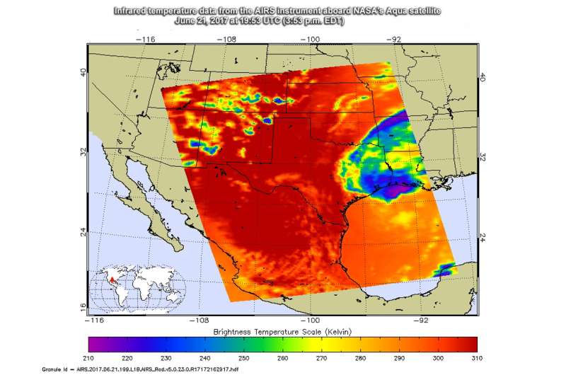
The Atmospheric Infrared Sounder or AIRS instrument aboard NASA's Aqua satellite looked at Tropical Depression Cindy in infrared light. The AIRS image was taken on June 21 at 19:53 UTC (3:53 p.m. EST) and showed some cloud top temperatures of thunderstorms near the center of circulation as cold as minus 63 degrees Fahrenheit (minus 53 degrees Celsius). NASA research has shown the storms with cloud tops that cold have the potential to generate heavy rainfall.
The infrared data was false-colored at NASA's Jet Propulsion Laboratory in Pasadena, California, where AIRS data is managed.
Cindy made landfall around 3 a.m. CDT in southwestern Louisiana. At that time, the National Hurricane Center or NHC said that Cindy was centered about 30 miles (45 km) west-southwest of Lake Charles, Louisiana.
Measuring Rainfall Rates from Space
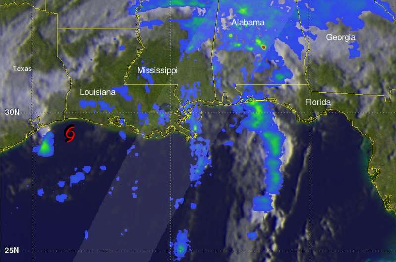
The GPM core observatory satellite passed above as Tropical Storm Cindy was approaching the western Louisiana coast on June 22, 2017 at 2:21 a.m. EDT (0621 UTC). Cindy had maximum sustained winds of about 40 knots (46 mph) at that time. Rainfall derived from Microwave Imager (GMI) and Dual-Frequency Precipitation Radar (DPR) measurements showed that there was very little rainfall near Cindy's center of circulation but bands of moderate to heavy showers were seen moving into the states along the Gulf Coast. GPM's Radar (DPR Ku Band) found that storms over central Alabama were dropping rain at a rate of over 3.6 inches (91 mm) per hour.
At NASA's Goddard Space Flight Center in Greenbelt, Maryland, GPM radar (DPR Ku Band) data were used to show the 3-D structure of rainfall within Cindy's storm tops. GPM's radar revealed that a few storms within rain bands near New Orleans were reaching heights of over 7.2 miles (11.6 km). GPM's radar found that the heaviest downpours over Alabama were returning radar reflectivity values of over 51dBZ to the GPM satellite.

Cindy's Whereabouts on June 22
On June 22, NHC issued a Tropical Storm Warning from High Island, Texas to Morgan City, Louisiana.
At 8 a.m. EDT (1200 UTC), the center of Tropical Storm Cindy was located near latitude 30.5 North, longitude 93.7 West. Cindy is moving toward the north near 12 mph (19 km/h), and a turn toward the north-northeast is expected later today, followed by a turn toward the northeast on Friday, June 23. Maximum sustained winds are near 40 mph (65 kph) with higher gusts. The estimated minimum central pressure is 994 millibars.
Rainfall is the Biggest Danger
The National Hurricane Center noted that rainfall is the biggest threat from Cindy as it continues to move inland. NHC said, "Cindy is expected to produce rain accumulations of 3 to 6 inches with isolated maximum amounts up to 12 inches over eastern Texas, western and central Louisiana, and southern and eastern Arkansas through Friday morning. Additional rainfall amounts of 2 to 4 inches with isolated maximum amounts of 8 inches over southern Mississippi, southern and central Alabama, and extreme western Florida Panhandle are expected through Friday morning. This rainfall could cause life-threatening flash flooding in these areas.
Rainfall is expected to begin and expand across parts of the Tennessee and Ohio valleys. Rainfall amounts of 1 to 2 inches with isolated maximum amounts of 4 inches are expected through Friday morning."
In addition to heavy rainfall, tropical storm force winds, storm surge and a few tornadoes are possible. The tornado threat extends through tonight, June 22, from the lower Mississippi and Tennessee Valley regions to the central Gulf Coast.
On the forecast track, Cindy will move into southeastern Arkansas early Friday, and into Tennessee later on Friday. NHC said Cindy is expected to continue weakening and should become a remnant low tonight.
Provided by NASA's Goddard Space Flight Center


