NASA finds wind shear weakening Hurricane Kenneth

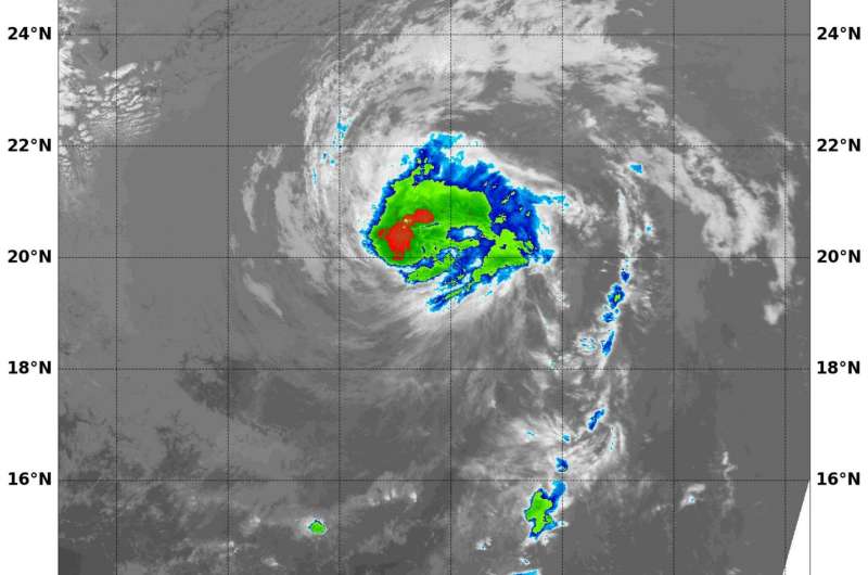
Hurricane Kenneth was quickly weakening early on Aug. 22 as a result of vertical wind shear. Infrared imagery from NASA's Aqua satellite showed that the strongest storms associated with the hurricane were pushed away from the center.
Hurricane Kenneth was quickly weakening early on Aug. 22 as a result of vertical wind shear. Infrared imagery from NASA's Aqua satellite showed that the strongest storms associated with the hurricane were pushed away from the center.
Wind shear is a measure of how the speed and direction of winds change with altitude.
On Aug. 22 at 6:45 a.m. EDT (1045 UTC) the Moderate Resolution Imaging Spectroradiometer or MODIS instrument aboard NASA's Aqua satellite provided an infrared image of Kenneth. Infrared satellite imagery showed a deteriorating system with warming cloud tops being affected by wind shear. When cloud tops warm, they are less high in the atmosphere, because the uplift of air weakened. It's a sign that the storm is losing strength.
Coldest cloud top temperatures were as cold as minus 70 degrees Fahrenheit (minus 56.6 degrees Celsius). NASA research indicates very cold cloud tops with the potential to generate very heavy rainfall.
The National Hurricane Center (NHC) noted that recent microwave images showed the inner-core structure has eroded and that the low-level center is displaced to the southwest of the mid-level center because of moderate southwesterly vertical shear.
At 5 a.m. EDT (0900 UTC) the center of Hurricane Kenneth was located near 20.0 degrees north latitude and 132.5 degrees west longitude. That's about 1,465 miles (2,355 km) west of the southern tip of Baja California, Mexico. Kenneth was moving toward the northwest near 10 mph (17 kph), and a turn toward the north-northwest is expected later today.
Maximum sustained winds have decreased to near 90 mph (150 kph) with higher gusts. The estimated minimum central pressure is 978 millibars.
The NHC expects Kenneth to continue weaken rapidly over the next day or two as it moves over cooler sea surface temperatures and into an area where wind shear is forecast to increase. NHC forecasters said Kenneth should weaken to a tropical storm later today and become post-tropical in 2-3 days, if not sooner.
Provided by NASA's Goddard Space Flight Center


