GPM satellite probes soaking storms in Southern Texas and the Gulf

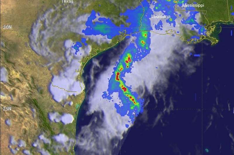
Southern Texas and the western Gulf of Mexico is getting a soaking because of a low pressure system. The Global Precipitation Measurement mission or GPM core satellite passed over the western Gulf of Mexico and measured the rainfall from the system.
The rainfall is expected to continue in the area through Wednesday evening, June 20.
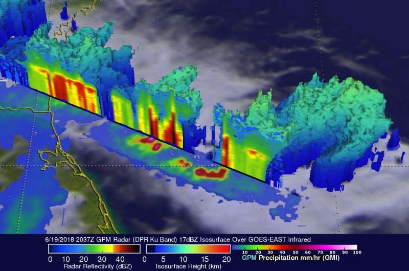
On June 19, 2018 at 3:37 p.m. CDT (2037 UTC) the GPM core observatory satellite passed over the western Gulf of Mexico. This GPM pass revealed extreme rainfall that was being produced in the northwestern Gulf of Mexico. GPM's Microwave Imager (GMI) and Dual Frequency Precipitation Radar (DPR) instruments probed powerful storms that were dropping rain at a rate of 3.5 inches (88 mm) per hour.
The GPM satellite's radar data (DPR Ku Band) collected data that were used here to show 3-D cross-sections of precipitation within storms located in the Gulf of Mexico east of Texas. These DPR probes revealed that some of these powerful storms were reaching altitudes above 7.75 miles (12.5 km). A few downpours were returning radar reflectivity values greater than 58 dBZ to the GPM satellite.
Algorithms developed by NASA's Precipitation Measurement Missions (PMM) science team at NASA's Goddard Space Flight Center in Greenbelt, Maryland were used to process the GPM satellite's radar data. GPM is a joint mission between NASA and the Japan Aerospace Exploration Agency, JAXA.
NOAA's National Hurricane Center in Miami, Florida issued a "Tropical Weather Discussion" at 1:40 p.m. EDT on June 20. The discussion noted that a low pressure area centered inland in the deep south of Texas near 27 degrees north latitude and 98 degrees west longitude, continues to produce a large area of showers and thunderstorms over the western Gulf coast. "Similar convective activity flared up over the west-central Gulf, particularly north of 21 degrees north latitude, west of 95 degrees west longitude.
This slow moving system will continue to deliver heavy rainfall and flooding along the coast of Texas into Louisiana. A widespread 3 to 5 inches of rainfall is possible over this region through Thursday morning, with isolated pockets of heavier amounts expected."

The National Weather Service of Corpus Christi, Texas has a number of warnings and watches in effect today, June 20. A Flash Flood Watch is in effect until June 21 at 6 a.m. CDT, a Flood Warning was in effect for Nueces County, Jim Wells County and Northern Kleberg County in south central Texas until 2:45 p.m. CDT, June 20. In addition, a Coastal Flood Warning remained in effect through June 21 at 12 a.m. CDT. The NWS noted there is a high risk of rip currents along gulf-facing beaches through the evening on June 20, and minor coastal flooding expected along the islands and area bays.
Because many areas in the Corpus Christi and southern Texas region have received over 5 inches of rainfall since Sunday, and any additional rainfall will only fall into already swollen or near swollen rivers and creeks as soils are saturated.
Provided by NASA's Goddard Space Flight Center


