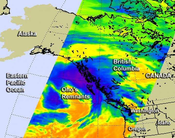
Former Hurricane Oho's remnants affecting western Canada, Washington state

NASA's Aqua satellite and NOAA's GOES-West satellite saw the remnants of former Hurricane Oho moving toward British Columbia, Canada and western Washington State. Oho was a hurricane in the Central Pacific Ocean that weakened, became extra-tropical and moved northeast.
An infrared image from NOAA's GOES-West satellite showed the clouds associated with former Hurricane Oho's remnants near southwestern Canada and Washington State on Oct. 9 at 1200 UTC (8 a.m. EDT). An animation of GOES-West imagery from October 6 through October 9 showed the weakening and movement of Oho from the Central Pacific Ocean to the coast of western Canada. The images and animation were created by the NASA/NOAA GOES Project at NASA's Goddard Space Flight Center in Greenbelt, Maryland.
On Oct. 9 at 6:53 a.m. EDT (1053 UTC) the Atmospheric Infrared Sounder (AIRS) infrared instrument aboard NASA's Aqua satellite showed the high, cold clouds and storms associated with Oho's remnants along the west coast of Canada, stretching south to the coast of Washington State.
On Friday, October 9, 2015, weather alerts were posted by Environment Canada for areas of British Columbia, and by the National Weather Service in Seattle, Washington for various areas.
Environment Canada's alert stated "Very strong southeasterly winds of 90 to 110 km/h associated with the remnants of Hurricane Oho have developed over Haida Gwaii." Haida Gwaii is an archipelago on the North Coast of British Columbia, Canada.
"These winds will spread to the North Coast - Coastal Sections, the Central Coast - Coastal Sections, and exposed sections of North Vancouver Island early this morning. The winds will ease later this morning to 50 to 70 km/h as the low continues to track northwards. Damage to buildings, such as to roof shingles and windows, may occur. High winds may toss loose objects or cause tree branches to break."
At 2 a.m. PDT on Friday, October 9, the extra-tropical remnants of Hurricane Oho were about 290 nautical miles west-southwest of Haida Gwaii.
At 6:34 a.m. EDT/3:34 a.m. PDT, the National Weather Service (NWS) in Seattle, Washington noted that a vigorous front will bring heavy rain and breezy to windy conditions Saturday and Saturday evening, October 11. The NWS discussion stated that (the remnants) "warm front offshore will move slowly through western Washington.
Most of the rain will be along the coast and in the Olympics and North Cascades (mountains) where amounts of 0.5 to 1.5 inches will be common. Locally up to 2.5 inches could fall in the Olympics. The western Washington interior lowlands will probably not get any rain until Friday afternoon (Oct. 9) and the totals through tonight will generally be less than 0.1 inch."
More information: For updated forecasts for Washington State, visit: http://www.weather.gov/ For updated forecasts and warnings for western Canada, visit: http://weather.gc.ca/warnings/index_e.html.
Provided by NASA's Goddard Space Flight Center


