Study reports enormous ice loss from Greenland glacier

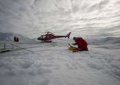
Ground-based measuring devices and aircraft radar operated in the far northeast of Greenland show how much ice the 79° N-Glacier is losing. According to measurements conducted by the Alfred Wegener Institute, the thickness ...

Satellite data assimilation improves forecasts of severe weather

In 2020, a line of severe thunderstorms unleashed powerful winds that caused billions in damages across the Midwest United States. A technique developed by Penn State scientists that incorporates satellite data could improve ...

Unlocking clearer views of our world's water: A Landsat legacy

Satellite remote sensing is vital for monitoring marine and freshwater ecosystems, leveraging missions like SeaWiFS, MODIS, MERIS, Landsat, and Sentinel to track water parameters such as chlorophyll, sediment, and temperature. ...

page 3 from 40